Shipwreck of the SS Maheno on K’gari (Fraser Island)
K’gari, formerly known as Fraser Island, is located around 250kms north of Brisbane and is one of Australia's favourite holiday locations. At 123km long and 22km at its widest point, it is famous for being the world's largest sand island and was declared a World Heritage Site in 1992. The following words in this article are taken from Wikipedia under Creative Commons licensing.

These are the way to get around Fraser Island if you don't have a 4WD
"The island has rainforests, eucalyptus woodland, mangrove forests, wallum and peat swamps, sand dunes and coastal heaths. It is made up of sand that has been accumulating for approximately 750,000 years on volcanic bedrock that provides a natural catchment for the sediment which is carried on a strong offshore current northwards along the coast. Unlike on many sand dunes, plant life is abundant due to the naturally occurring mycorrhizal fungi present in the sand, which release nutrients in a form that can be absorbed by the plants. Fraser Island is home to a small number of mammal species, as well as a diverse range of birds, reptiles and amphibians, including the occasional saltwater crocodile. The island is protected in the Great Sandy National Park."

You won't find many people swimming here due to the local shark population
"Archaeological research and evidence shows that Aboriginal Australians occupied K’gari at least 5,000 years ago. There was a permanent population of 400–600 that grew to 2,000–3,000 in the winter months due to abundant seafood resources. The arrival of European settlers in the area was an overwhelming disaster for the Butchulla people. European settlement in the 1840s overwhelmed the Aboriginal lifestyle with weapons, disease and lack of food. By the year 1890, Butchulla numbers had been reduced to only 300 people. Most of the remaining Butchulla were taken off the island in 1904 and relocated to missions in Yarrabah and Durundur, Queensland. It is estimated that up to 500 indigenous archaeological sites are located on the island."

Still standing strong in the face of adversity
"In October 2014, Native title rights were granted to the Badtjala people by the Federal Court. This essentially enabled the indigenous people to hunt, fish and take water for domestic purposes; and could open the island up to economic opportunities for current and future generations of Butchulla people through ecotourism and related business development."

There are rumours this wreck was used as aerial bombing target practise
"Initial European contact was limited to explorers and shipwrecks. The first recorded Britisher to sight K’gari (Fraser Island) was James Cook who passed along the coast of the island between 18 and 20 May 1770. He named Indian Head after viewing a number of Aboriginal people gathered on the headland. After Cook's passage the Aboriginals composed a song to commemorate the event. This was later recognized as the first preserved oral testimony of indigenous observation of Europeans. Matthew Flinders sailed past the island in 1799, and again in 1802, this time landing at Sandy Cape, while charting Hervey Bay. His 1814 chart is a combination of both voyages, but did not confirm K’gari (Fraser Island) as being separate from the mainland. However, Flinders did suggest the presence of shallow swampy areas at the lower part of the bay. Flinders was told of an opening at Hook Point, between K’gari (Fraser Island) and the mainland, by two American whalers who were hunting whales in Hervey Bay. In 1842, Andrew Petrie recorded good pastoral lands and forests, attracting graziers to the region. Lieutenant Robert Dayman was the first European to sail between Fraser Island and the mainland in 1847."

At the rate of erosion the wreck might not be visible in another 50 years
"The name Fraser Island comes from Eliza Fraser and her story of survival from a shipwreck on the island. Captain James Fraser and his wife, Eliza Fraser, were shipwrecked on the island in 1836. Their ship, the brig Stirling Castle, set sail from Sydney to Singapore with 18 crew and passengers. The ship was holed on coral while travelling through the Great Barrier Reef north of the island. Transferring to two lifeboats, the crew set a course south, attempting to reach the settlement at Moreton (now Brisbane).

SS Maheno - up close and personal
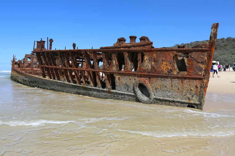
"A major landmark on K’gari (Fraser Island) is the shipwreck of the S.S Maheno. The Maheno was built in Scotland in 1905 as a luxury passenger ship for the Trans-Tasman crossing. During the First World War she served as a hospital ship in the English Channel, and was then returned to her owners to resume her usual commercial operation. By 1935 the ship had been taken out of service and was sold to a ship-breaker in Japan. On 25 June 1935, while being towed to Osaka to be broken up, she was caught in a strong cyclone about 80 kilometres (50 miles) off the coast of Queensland. The towline parted, and on 9 July 1935 the Maheno became beached on the east coast of Fraser Island."

If only this wreck could speak, would love to hear it's stories
"During the Second World War the wreck served as target bombing practice for the RAAF (Royal Australian Air Force) and was used as an explosives demolition target by special forces from the Fraser Commando School. The remains of the ship are now severely rusted, with almost three and a half storeys buried under the sand. Because of the danger it poses, climbing on the wreck is not permitted."

I promise, only one more wreck photo after this one

Long view from the bow to the stern
"The coloured sands found at Rainbow Gorge, The Cathedrals, The Pinnacles and Red Canyon are examples of where the sand has been stained over thousands of years due to the sand conglomerating with clay. Hematite, the mineral pigment responsible for the staining acts like cement. This allows the steeper cliffs of coloured sand to form. Coffee-rock, so-called because when it is dissolved in water it turns the colour of coffee, is found in outcrops along the beaches on both sides of the island."

The multi-coloured sand of The Pinnacles

Only a short 5 mins stroll to The Pinnacles and back
"Eli Creek is the largest freshwater creek on the east coast of the island with a flow of 80 million litres per day. Eli Creek has its own unique and varied wild life."

A popular spot for tour buses and day trippers to stop for lunch

The boardwalk at Eli Creek takes you on a circuitous journey
"Logging on the island began in 1863, initiated by American Jack Piggott (known as 'Yankee Jack'). Piggott's contribution, however, was limited as he was killed the following year by Aboriginals on the northern part of the island after what was rumoured to be a "black-shooting expedition" went awry. Blackbutt trees (Eucalyptus Pilularis), Queensland kauri (Agathis Robusta) and Satinay or Fraser Island turpentine (Syncarpia Hillii) were extensively exploited as they provided excellent timber. Satinay logs were sent to Egypt to be used in the construction of the Suez Canal."

Everyone from the young to the old can walk through the freshwater creek

Take the upper boardwalk if you need the toilets

A partial skull of a whale about a 5min walk south from Eli Creek

Partial skeletal remains of a whale near Eli Creek
"The geological wealth of the island lay in its rich deposits of rutile, ilmenite, zircon and monazite. Sand mining leases were first granted in 1950, and mining continued until 1977. Without public knowledge the Queensland Government granted mining leases to the American mining company Dillingham-Murphyores in the 1960s. In 1971, the Fraser Island Defense Organisation (FIDO) opposed the granting of more leases to the company. Despite more than 1,300 submissions that were made to the local mining warden objecting to new leases, the submission was granted. FIDO took the case to the High Court of Australia which overruled the decision noting that the public interest was not being upheld. Dillingham-Murphyores continued mining. The Whitlam Government established Australia's first environmental impact inquiry which recommended that mining cease."

Whale skull up close near Eli Creek

Eli Creek is popular with families who have kids as the swimming's safe
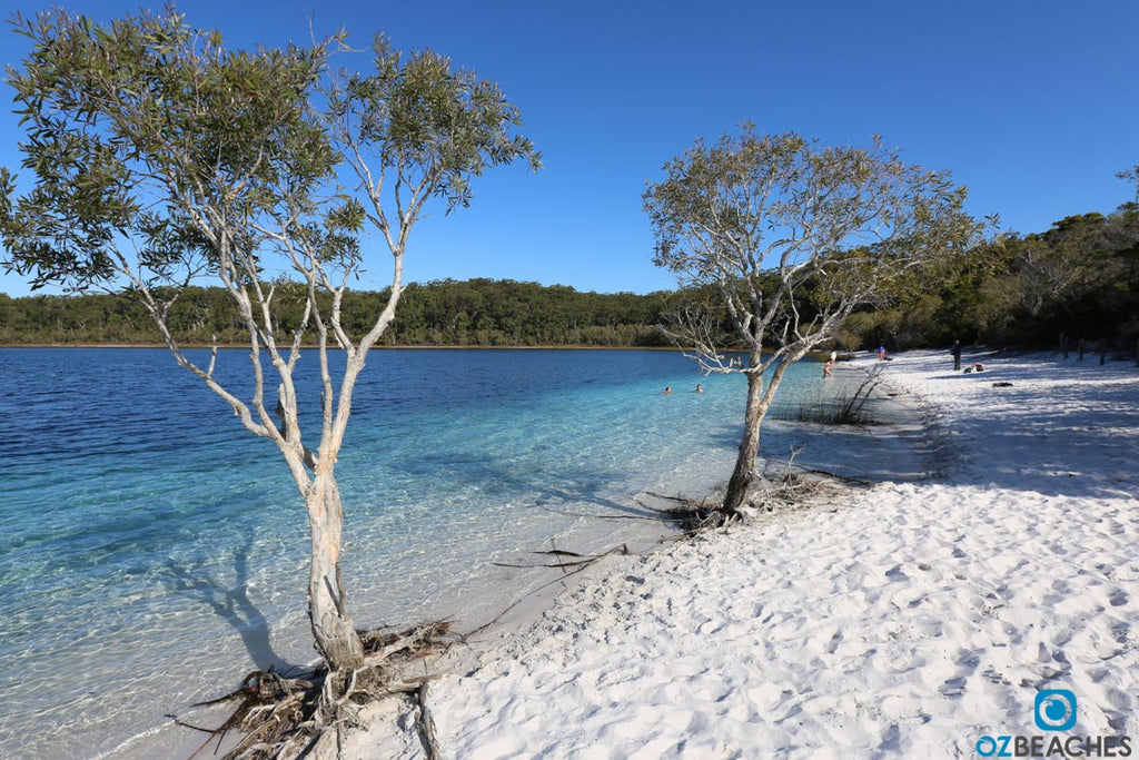
"Fraser Island has over 100 freshwater lakes, which is the second highest concentration of lakes in Australia after Tasmania. The freshwater lakes on Fraser Island are some of the cleanest lakes in the world. A popular tourist area is Lake McKenzie which is located inland from the small town of Eurong. It is a perched lake sitting on top of compact sand and vegetable matter 100 metres (330 ft) above sea level. Lake McKenzie has an area of 150 hectares and is just over 5 metres (16 ft) in depth. The beach sand of Lake McKenzie is nearly pure silica."

You can see where it gets its name from
The irresistable waters of Blue Lake on Fraser Island
"Dingoes were once common on the island, but are now decreasing. The Fraser Island dingoes are reputedly some of the last remaining pure dingoes in Eastern Australia and to prevent cross-breeding, dogs are not allowed on the island. According to DNA-examinations from the year 2004, the dingoes on Fraser Island are "pure". However, skull measurements from the 1990s detected crossbreeds between dingoes and domestic dogs among the population."

Blue Lake is a popular stop off for the tour buses and gets crowded
"Up until 1995, there were no official records of dingoes attacking humans on Fraser Island. In April 2001, a boy named Clinton Gage wandered away from his family and was attacked and killed by several dingoes. Over 120 dingoes were killed by rangers as a result of the incident, though locals believe the number was much greater. After the 2001 attack, four dedicated rangers were allocated dingo management roles and ranger patrols were increased. There are fines for feeding dingoes or leaving food and rubbish out which may attract them."

But you can still get a piece to yourself if you're prepared to walk a little
"Estimates of the number of visitors to the island each year range from 350,000 to 500,000. The chance of seeing a dingo in its natural setting is one of the main reasons people visit the island. The use of boardwalks and marked tracks by visitors is encouraged to reduce erosion. Everyone who hires a vehicle on the island from an organisation accredited by the Fraser Coast 4WD Operators Association must attend a one-hour-long briefing on vehicle safety."

Looks even more inviting when there's no wind and the surface is like glass
Situated off the coast from Hervey Bay, Fraser Island is around a 3 hour drive north of Brisbane. If driving yourself, you can reach the island by car ferry from the mainland or simply visit one of the many tour operators in Hervey Bay and strap yourself in for a day of fun on a 4WD bus.
Hervey Bay is the next region north from Fraser Island
Rainbow Beach is the next beach south from Fraser Island
I hope you enjoyed reading this article. Fraser Island is undoubtedly the most amazing (and largest) sand island in the world. Famous for its endless beaches, 4WD'ing and camping, the wreck of the SS Maheno, plus its colourful lakes and ancient forests, there's plenty to see and do on this remarkable island off the coast from Hervey Bay.
All photos in this article are available for purchase in various sizes as high resolution acrylic glass or canvas prints, and are available for licensing purposes for media and marketing/promotional material. The photos you see here have been compressed for optimal online user experience, which means we've intentionally reduced the file size and quality of each image to ensure the pages you visit load faster.
Any printed reproduction of the photos you see on OZBEACHES would be done using the original 20+ megabyte RAW files, with the additional layer of having a professional graphic designer personally inspect each image and optimise for print. The OZBEACHES watermark would be removed and would not be visible on your print. If you have any questions about this process, please email me (Adam) and let me know which photo you're interested in by quoting the caption beneath it. Alternatively you can check out our featured images in the print gallery.
If you think Fraser Island is a place you'd like to visit with your friends, why not share this article with them via one of the social links below. I want to help people (including you!) find their dream Australian beach, and the more information we share together will ultimately help us all in achieving that goal. I hope you enjoy your search.
Cheers,
Adam
Sign up to get the latest on sales, new releases and more …
© 2026 OZBEACHES.